JULY 9
Leveraging Land Cover Maps for Near Real-Time Assessment of Climate, Financial, and Environmental Risks
Land use and land cover mapping plays a vital role in understanding the dynamics of our environment and the potential risks associated with climate change, financial investments, and environmental sustainability. With the advent of advanced remote sensing technologies and near real-time data availability, land use and land cover maps have become invaluable tools for monitoring and assessing risks promptly.
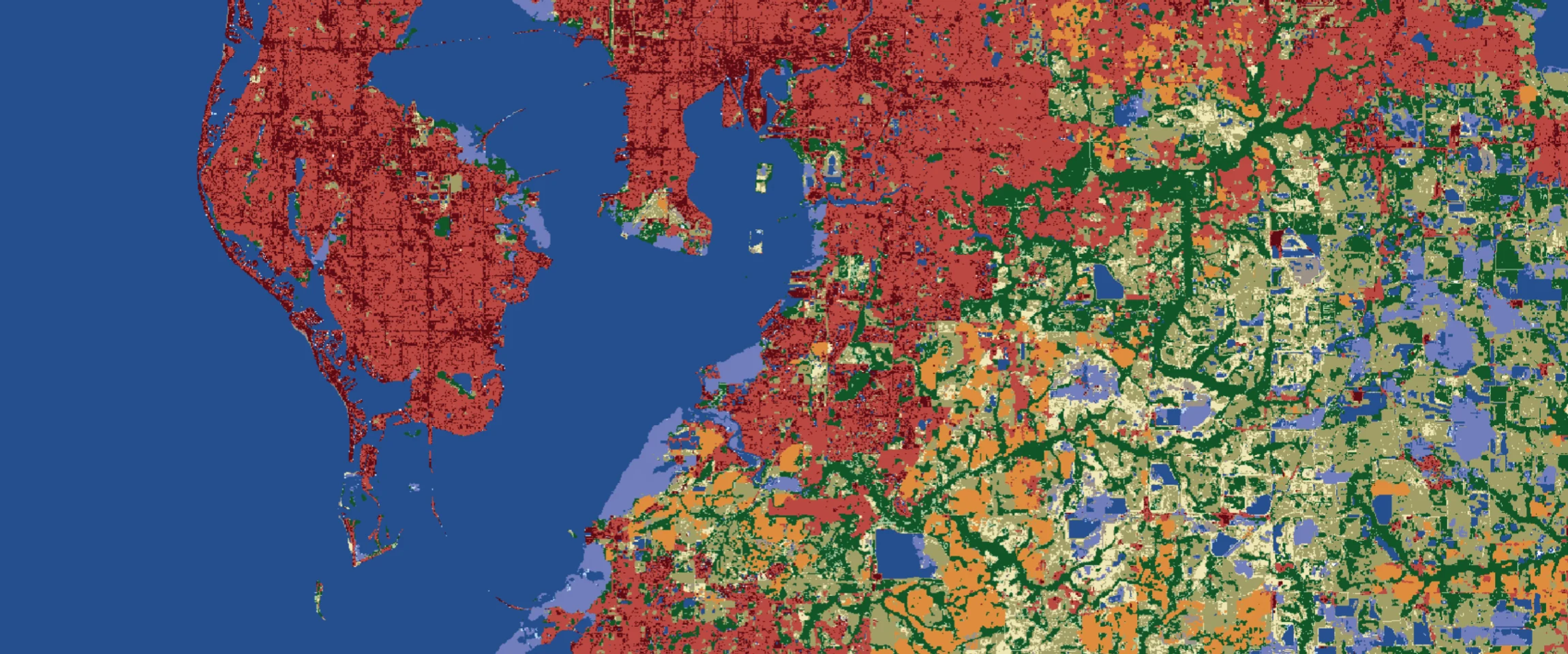
The displays a nine-class land cover map, visually representing different land cover types. It plays a vital role in understanding climate, financial, and environmental risks by providing insights into water bodies, forests, crops, built areas, and more. This near real-time monitoring tool enables proactive decision-making and targeted mitigation strategies for a resilient future.

Access the Land Use Map Bundle here.
Climate Risk Assessment
Land cover maps contribute to climate risk assessment by providing insights into the distribution and characteristics of different land cover types. Monitoring water bodies, forests, rangelands, flooded vegetation, crops, built areas, bare ground, snow/ice, and clouds allows for a comprehensive understanding of climate-related vulnerabilities. For example, areas with a high percentage of built-up areas might indicate urban heat island effects, while changes in water bodies and vegetation cover can signal alterations in hydrological cycles and potential drought or flood risks. By continuously analyzing land cover changes, policymakers, scientists, and communities can proactively plan adaptation strategies and mitigate climate-related risks.
Financial Risk Analysis
Land use/land cover maps are helpful tools for assessing financial risks associated with investments and resource management. Understanding the distribution of different land cover categories aids in evaluating the economic viability and sustainability of various sectors. For instance, monitoring changes in crop cover can provide early warnings about potential agricultural yield fluctuations, influencing commodity prices and impacting financial investments in the agricultural sector. Assessing land cover changes in urban areas can inform real estate investments, infrastructure development, and insurance industry decisions. By integrating land use and land cover information into financial risk analysis, stakeholders can make informed decisions that consider the potential impacts of changing land cover on economic stability and investments.
Environmental Risk Evaluation
Land cover maps facilitate the evaluation of environmental risks across different categories. Mapping water bodies enables the assessment of water quality, monitoring pollution sources, and identifying potential ecological risks. Analyzing changes in forest cover and biodiversity-rich areas helps identify habitat degradation, deforestation, and encroachment risks. By monitoring rangelands, land degradation and overgrazing can be identified, allowing for proactive land management practices. Furthermore, assessing the extent of built-up areas aids in understanding the urban sprawl and its impacts on ecosystems and natural resources. By comprehensively evaluating environmental risks through land use/land cover mapping, conservation efforts, sustainable land management, and ecosystem restoration initiatives can be prioritized and implemented.
Near Real-Time Monitoring
The availability of near real-time land use and land cover maps allows for timely monitoring of changes and risks. By utilizing satellite data and advanced image processing techniques, land cover information can be updated frequently, providing up-to-date insights. Near real-time monitoring facilitates early detection of potential risks, enabling swift response and mitigation measures. For example, identifying changes in vegetation cover can help detect forest fires, insect infestations, or disease outbreaks, allowing for prompt intervention. Continuous monitoring of land cover categories in flood-prone areas can support early flood warnings and response planning. Near real-time analysis enhances decision-making processes, enabling proactive measures to address climate, financial, and environmental risks promptly.
Land use and land cover maps offer a powerful tool for understanding climate, financial, and environmental risks in near real-time. By analyzing water bodies, trees, rangelands, flooded vegetation, crops, built areas, bare ground, snow/ice, and clouds, stakeholders can gain valuable insights into potential vulnerabilities and devise strategies to mitigate risks. The integration of land use/land cover mapping into risk assessment processes empowers decision-makers to proactively identify vulnerable areas, implement targeted mitigation strategies, and foster sustainable development practices for a resilient future.