SkyFi vs. Google Earth: What’s the Difference?
Wondering about the difference in resolution between SkyFi & Google Earth images? How an image is captured, whether by a satellite or aircraft, greatly impacts its resolution. Read our article about the difference between satellite and aerial images.
You Know Google Earth — Now Meet SkyFi
Since its debut in 2005, Google Earth has taken planet-sized strides in generating awareness around satellite imagery, and we thank them for that. Now, SkyFi aims to take that awareness and fly straight to the moon with it. While Google certainly has its place here on Earth, you’ll quickly find that SkyFi isn’t a one-to-one Google Earth alternative. Much of that difference lies in recency, data-rich image files, and diversity of sensor types— all factors that elevate SkyFi well above what we used to expect from Earth observation imagery.
What Makes SkyFi Different?
Both Google Earth and SkyFi leverage the power of satellite imagery to provide planet-spanning views from above. Both platforms are easy to access as long as your device, be it mobile or desktop, is connected to the internet. We’re alike in those ways, but worlds apart in plenty of others.
With an ever-growing network of partners, SkyFi’s satellites are able to provide views of nearly anywhere on the planet’s surface. SkyFi is more about giving users like you the power to capture satellite images at a chosen resolution, during a desired time frame, and in a specific place. Users can then choose to purchase those images at an affordable price and download them directly to their favorite device. Beyond a standard daytime image, SkyFi’s technology allows images to be captured using a wide variety of satellite sensors – giving users the tools they need to take on a diverse range of challenges.
At the end of the day, Google Earth is essentially a geobrowser, which is exactly how Google positions it. As a free tool, it finds its utility in the educational realm, as a platform for virtual tourism, and as a place to crowdsource data by allowing users to share location-related images of their own.
SkyFi differentiates itself by catering to both business-oriented power users and people who are just beginning to dabble with the possibilities of Earth observation imagery. Sectors like real estate, finance, and energy can leverage the specificity and flexibility of SkyFi to review assets and monitor performance on the ground. Meanwhile, those of us just looking for a bit of fun or a spark of creativity can use it to capture memories in a wholly unique format, scope out our next adventures, or even make long-lasting digital art.
SkyFi Delivers the Here and Now
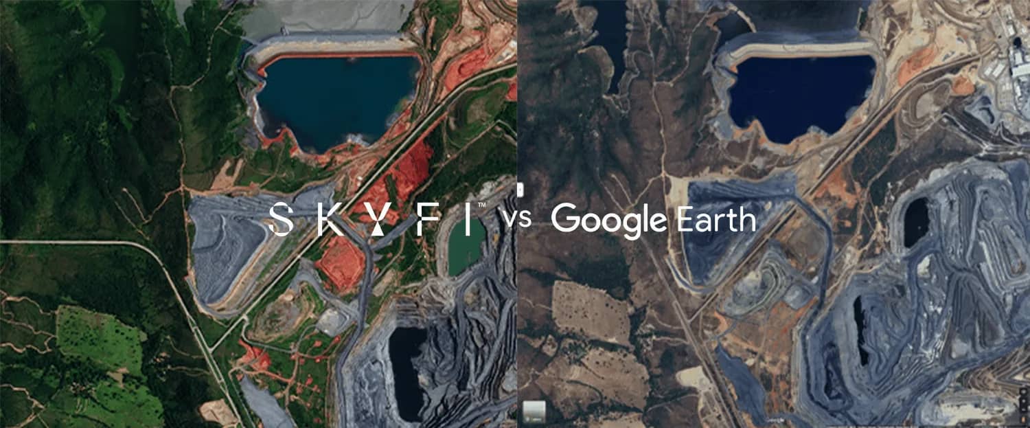
At SkyFi, our satellites capture images daily, while Google Earth’s images average between one and three years in age. With more up-to-date visual awareness, you have the power to choose the desired moment in time for your satellite image. That means you have access to an awe-inspiring image of your wedding or that special hiking spot where you proposed during your favorite season. And when it’s time to get down to business, SkyFi is not only the easiest way to see today, it’s your enterprise’s best bet for the most accurate data to-date.
And we’ve got more of those moments, too. SkyFi lends a bird’s eye view of any place on the planet, whereas Google Earth’s often years-old images only encompass a little more than 60% of Earth’s land surface. Seriously, our CEO’s neighborhood isn’t even on Google Earth.
A Feast for the Senses (and Sensors)
Image-wise, you’ll also find that SkyFi provides a more robust experience than its peers, browser-based or otherwise, thanks to a wide variety of imaging technologies. Powered by multiple data sources, our integrated platform allows us to have more options for the level of resolution you want and more choice of sensors compared to other platforms. In terms of options, Google Earth, like many other mapping services, only offers a daytime optical view. What that means is you see what the camera lens sees, as though you were looking through the camera on your mobile device.
With SkyFi, you have the option of optical satellite imagery as well as multispectral and video, and we’re continuously adding new imaging technologies to our virtual constellation. These advanced sensors often cater to the needs of geospatial experts, but SkyFi’s aim is to make them accessible and usable for everyone, all on the same platform.
So Why SkyFi?
As a broader experience, Google Earth doesn’t enable you to pinpoint moments like the day of your kid’s first soccer match or the exact place you and your best friend reached that gnarly summit. When you SkyFi it, you can do that. Similarly, SkyFi users have access to our partners’ full Existing Image library. So if you want to peruse a month of progress at a particular location, there’s a good chance we can do that, too.
No disrespect, but Google Earth is the thing you use when you need a quick, casual glance at the world beyond your reach. We’re not a Google Earth alternative. We’re the solution where everyone can order out-of-this-world images of our Earth from anywhere, on demand. Don’t let the bounds of Earth limit your creativity or curiosity. When in doubt, SkyFi it.
Sources
Carleton College Science Education Resource Center — What Is Google Earth?
Google Earth — Google Earth Is Born
Google Earth — Overview