
Tracking Mining's Environmental Footprint with SkyFi and Picterra
The Question:
What is the impact of mining on forests?
Use case:
Identifying the impact of mining on forests by using temporal satellite imagery to detect change over a period of time.
Mining’s direct impacts on forests include land-use change at mine sites, downstream pollution, and environmental damage. The sector also has a significant indirect impact that extends outside of the mine sites - the World Bank studies mentioned below indicated evidence of forest loss within a radius of 50 km of most of the mines, and in some cases of up to 100 km. The indirect impacts include ie. those associated with the development of road, rail, and port infrastructure for the transport and export of minerals, and the impacts associated with an influx of workers and other economic activities such as logging as infrastructure opens forests up.
While investors and consumers are increasingly aware of the sector’s forest, biodiversity, and wider climate impacts, the mining companies are increasingly accepting responsibility for direct forest impacts, setting environmental impact mitigation targets and reporting on them.
An analysis by the World Bank suggests that 44% of all operational mines lie in forests.
This represents 1,539 mines, with another 1,826 in development or currently inactive.
Mining activities have driven 7% of deforestation, according to a 2012 assessment.
The audience
Mining companies care.
Mining companies have a responsibility to monitor their impact on the environment and reduce their environmental footprint throughout the mine's lifecycle. By monitoring deforestation change over time, mining companies can better understand the impact of their operations on the surrounding land, flora, and fauna, and take proactive measures to reduce their environmental impact. This not only helps to mitigate climate change risks but also supports sustainability efforts, reduces waste and emissions, and promotes responsible business practices.
The Answer
The Data
Optical Satellite Data
To effectively monitor deforestation from mining and its impact on forests, satellite imagery can be combined with geospatial analytics to provide accurate and science-based data records and intelligence. SkyFi provides access to millions of Existing Images and the capability to capture New Images of future dates through our web or mobile app.
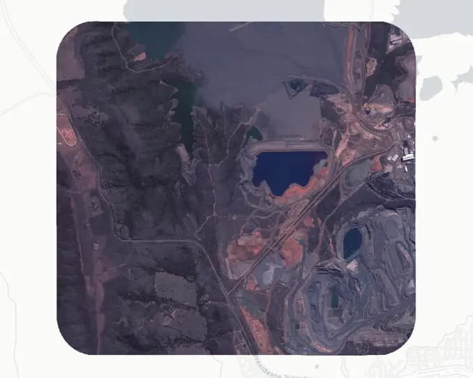
In this use case, two Existing Images of the exact same location were used, captured one year apart, to detect the change in the environment over time. The optical, 50 cm satellite images were able to capture changes in an area of interest that measured 20 km², which was large enough to show significant changes in forestry over time. The two Existing Images available on the SkyFi platform cost $100 each.
The Analysis
Change Detection Analytics
With the Picterra platform, users can create custom deep-learning models that enable mining companies to streamline geospatial analytics to monitor their environmental footprint, improve safety, and reduce risk in mining operations.
Once optical satellite data is acquired, the next step is to analyze the imagery using a change detection machine learning model. A change detection model is a technique that compares images of the same location captured at different times to identify any changes that have occurred over that period. The model is built on the principle of image differencing, which involves subtracting one image from another to reveal areas of change.
The model looks at both images and learns the variety of properties defining the change from the training dataset which can include, for example, color and brightness. Once the model is trained it can be deployed at scale and identify the areas where the change occurred.
The Application
By combining optical data and a change detection model, mining companies can effectively monitor deforestation and other environmental impacts of mining, and develop mitigation processes to alleviate these impacts. Picterra's deforestation from mining detector specifically addresses the challenge of monitoring deforestation from mining by detecting and mapping the total deforested area following mine expansion from date 1 to date 2.
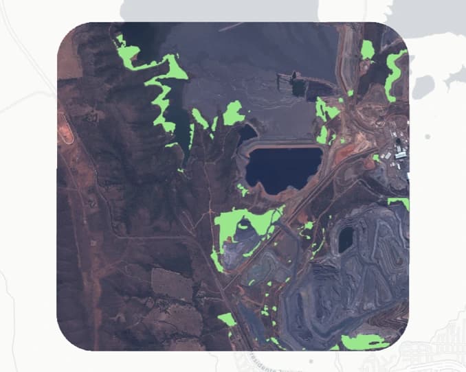
This change detection is done by taking the two images, and then automatically identifying and highlighting the parts that have changed.
It utilizes multivariate alteration detection methods, with built-in normalization through correlation. Such a model will disregard non-relevant changes between the images, and instead, highlight the actual changes of interest, such as deforestation or mine expansions. The strength of this type of methodology is that it can be used to detect many different types of changes in a wide range of imagery and is not limited to a single use case.
Click here to interact with the live report produced by Picterra.

Below is what happens when you apply the analytics. The green area represents trees that had been removed from the forest due to the mine expansion.
The Benefit
By utilizing geospatial analytics from Picterra and satellite data from SkyFi, mining companies can effectively monitor and, in return, inform mitigation decisions around the environmental impact of mining on forests. The data and insights provided can support transparent environmental reporting, the development of mitigation processes to alleviate the impacts of mining on nature, including forests, and drive forest-smart mining practices.
This allows them to make more informed decisions on how to manage their operations, reduce their environmental footprint, and ensure compliance with environmental regulations. By using the insights and data provided by geospatial analytics, mining companies can develop targeted mitigation strategies and forest-smart mining practices that minimize their impact on the environment.
The benefits of using geospatial analytics for mining companies extend beyond environmental considerations. They can also improve the safety and efficiency of mining operations, reduce risk, and optimize their workflows. By streamlining geospatial AI analytics, mining companies can gain valuable insights into their operations and make more informed decisions that lead to better outcomes. Ultimately, geospatial analytics helps mining companies maximize their potential while minimizing their environmental impact, and supports the transition to a decarbonized, sustainable economy.