SEPTEMBER 8
Case Study: How SynMax Uses Satellite Imagery To Stabilize Energy Trading
At SkyFi, when we say that we’re democratizing satellite imaging, it’s key to remember that democracy includes everyone — from the satellite-curious individual to prosumer enthusiasts to high-level enterprise users. SynMax, our sister company and one of our very first clients, is an exciting example of the latter. These finance industry and geospatial intelligence innovators have been using satellite imagery to provide industry insiders and hedge funds with data that helps them maneuver through volatile oil and gas markets. Here’s how SkyFi empowered SynMax to make informed decisions by applying new techniques to existing satellite technology.
Introducing SynMax
SynMax’s mission is to leverage qualitative analytics to turn large and diverse data sources into strategic and actionable insights. Essentially, they’re an intelligence group that helps businesses and private organizations make decisions backed by remotely sensed data. By feeding thousands of images into machine learning software, SynMax is able to pull data (such as the number of ships on the ocean, for instance) from satellite imagery.
Some of their key areas of expertise include dark ship detection (identifying vessels that have turned off their tracking beacons, an important factor to prevent illegal fishing, smuggling and even human trafficking), monitoring liquefied natural gas shipments, and identifying natural gas fracking operations in the U.S. With data in hand, SynMax’s team of experts is able to help clients navigate critical decision-making processes, like intervening in illicit maritime activities or evaluating multimillion-dollar investments.
Why Satellite Imaging Is Essential to Energy
For traders, investors and analysts in the energy industry, keeping track of global availability, production and flow is absolutely crucial for anticipating trade. By nature, though, operations in the oil and gas industries are extremely spread out across the globe. Traditionally, this has made aircraft-based intelligence collection prohibitively expensive. That’s where cost-effective satellite imagery, made easily accessible by SkyFi, comes into the picture. Our unprecedented affordability opens up high-quality satellite imaging to energy traders, who are often focused on cost optimization and almost always emphasize quick, accurate data.
A Question of Stability
Energy companies and traders rely on intelligence to assess everything from production volume to future investments, all of which were previously based heavily on projections and opinions. This guesswork often leads to infamous, and damaging, “boom and bust” cycles. As SynMax Chief Technology Officer Eric Anderson stated in a recent interview with Digital Oil and Gas, “We don’t have enough oil and gas, so the energy industry ramps up efforts and produces way too much oil and gas. Then there is a bust that causes damage to everyone involved.”
The problem of boom and bust is an issue of stability; stability comes from information, while instability often arises from rampant speculation. Without solid information, energy traders operate in a bubble, lacking vital information about what production will look like. For commodity traders, that often means trading on the grounds of a completely uncertain supply and demand cycle.
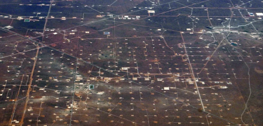
Or at least, it used to. With access to satellite imagery, SynMax has developed a model that will allow traders to understand when energy operations come online and how much they are expected to produce over the following two to three months. By incorporating massive amounts of daily satellite data into their regular analysis of fracking activity, SynMax can use that imagery to monitor hundreds of well pads for hydraulic fracturing equipment and frac crews.
Leveraging this data not only empowers traders, it helps limit boom and bust cycles down the line. Speaking to Via Satellite, SynMax owner Bill Perkins says, “Supply is so critical to price that once this [frac crew] data becomes available to the market, we believe that hedge funds will be unable to trade without it.”
Space-Based Imagery, Ground-Level Applications
Until recently, only government entities had access to high-resolution satellite imaging, and even then at a cost of billions of dollars. The introduction of smaller, cheaper commercial satellites changed that by introducing low-Earth orbit devices which were able to rival the imagery of the government’s larger satellites at a much more accessible price point. Likewise, SpaceX’s entry into the satellite sphere enabled a wider range of companies to launch greater numbers of satellites into orbit at more affordable rates.
The imagery — or visual data — those commercial satellites provide helps address some key challenges here on Earth. In fracking, analysts can solve massive object-detection problems using satellite images in order to identify well pads, the prepared sites where drilling processes occur. Likewise, satellite views help track the movement and dispersal of fracking crews and equipment daily — something that had previously been nearly impossible.
Satellite-Powered Decision Making
With access to reams of satellite-acquired data, SynMax uses machine learning to analyze the imagery — a particularly handy tool when processing the location data of literally tens of thousands of well pads. This creates a predictive data model that, for instance, empowers hedge funds to make informed predictions about natural gas production and market reactions.
SynMax has even built a program to track the energy industry in Ukraine via constant satellite monitoring of power plants, pipe lines, fuel storage tanks and related infrastructure. This data is funneled into a visual dashboard that keeps track of damage and operating capabilities in real time, facilitating informed online chat and offering easy sharing among users. In February 2022, that satellite-powered dashboard pinpointed the exact location of a pipeline explosion. By determining that the pipeline was not vital to the overall delivery infrastructure, observers were able to take confidence that there wouldn’t be significant disruption to the industry. That data would’ve been equally helpful had the opposite been true.
The Future of Satellite Imagery in Energy
While these applications are just a few examples, Anderson looks forward to broadening satellite-derived data applications even further: “Producers should be analyzing this data to better predict supply and forecast future budgets. Regulators should be analyzing this data as they monitor the industry to ensure rules are being followed. Service providers should be analyzing this data to help direct them on where resources are needed.”
That proliferation, Anderson hopes, will come with understanding. “The potential of satellite imagery is completely underappreciated, probably because people don’t understand just how accessible it’s going to be very shortly with the launch of SkyFi. I think we’re going to see a huge number of use cases and creative uses that we would never think of from satellite imagery once people become comfortable with the idea that it’s available to them at their fingertips.” And that’s a future that we can’t wait to witness — from a bird’s eye view, of course. Download SkyFi now to ehance your business with high-resolution, real-time satellite imagery.
Sources
SynMax — About Us
Digital Oil and Gas — Interview with Eric Anderson of SynMax
LinkedIn — The Power of Satellite Imagery with Eric Anderson, CTO at SynMax
Via Satellite — Planet Works with SynMax for Energy Intelligence and Dark Vessel Monitoring