How Satellite Imagery Helps Prevent Wildfires
By Dan Ketchum
Since 1983, the Environmental Protection Agency and the National Interagency Fire Center have reported an average of about 70,000 wildfires per year in the United States. In California alone, 15 of the 20 most destructive fires in state history have occurred since 2015, just one barometer of the growing frequency, mass and severity of these fires, which are both an indicator and a symptom of global climate change.
With a shot from the stars, though, we find new glimmers of hope in our abilities to predict, track and fight fires. Satellite images made accessible by SkyFi and our partners can not only observe wildfires as they happen, they may just be able to lend a hand to wildfire mitigation in the future.
Wildfire Season: A Growing Threat with Mounting Costs
As natural occurrences, wildfires have always existed on Earth. But over the decades, an explosive concoction of climate change, the increased presence of fire-starting fuels in the forests of the Western U.S., and more people living closer to high-hazard areas has completely changed the face of wildfire season. As the climate has warmed, wildfire season has grown longer while some of the driest spans in recorded human history have made volatile regions that much more vulnerable.
Per data from Resources for the Future, the annual area burned by wildfires in the U.S. increased by about 192,000 acres per year between the period of 1991 to 2020. In the Western U.S., the average area burned has increased by roughly 1,200% during the same span.
With increases to that activity come significant increases in the loss of natural resources, human and animal life, property damage and the costs of wildfire management. For instance, while about 5,200 structures were destroyed by wildfires in 2011, 17,900 were lost in 2020; while the federal government commonly spent $1 billion to $1.5 billion per year on wildfire mitigation throughout the 1990s, spending upward of $3 billion annually is no longer out of the question.
Satellites and Wildfires: Applications in Action
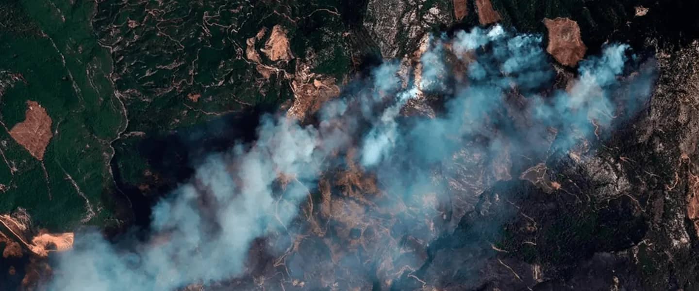
As powerful fleets of remote imaging sensors orbit hundreds of miles above our planet’s surface, satellite image marketplaces like SkyFi open up a bevy of immediate, practical applications. These can be useful — and even life-saving — for the average citizen, business operator, aid organization or government. In critical situations like these, having high-powered satellite “eyes on the ground” can:
Drastically improve response times; some satellites equipped with thermal infrared cameras can report any fire larger than 33 feet within one hour of ignition.
Reference real-time imaging to assist officials, fire departments, media and citizens in tracking wildfires as they move.
Reduce the need to put lives at risk for up-close wildfire monitoring and reporting.
Help disaster response teams deploy more efficiently to the areas where they’re needed most — and to navigate to those spots more safely.
Lessen the need for helicopter pilots to survey fire lines.
Allow governmental, nonprofit and real estate organizations to better respond to land management and rebuilding efforts post fire.
A Broader View of Wildfire Mitigation
While you don’t have to be a climate activist or a scientist to benefit from the power of satellite imagery during wildfire season, these experts can leverage the data provided by remote sensors to make substantial differences in how we respond to wildfires over the long haul. For example:
SkyFi users have access to our partners’ full archive of previously-captured images. Over time, satellite imaging data may help artificial intelligence systems predict the course of future wildfires.
Current satellite systems have a high revisit rate, which means they can monitor landscapes – and in this case, fires – multiple times per day rather than the once-per-day data collection of the past; this also leads to more accurate forecasting systems, especially for bigger, more dynamic wildfires.
Observing pre-fire conditions and comparing those conditions to the severity of ensuing wildfires can also help bolster forecasting accuracy.
Tracking and analyzing the surrounding spot fires, air particles, wind patterns and cloud cover not only helps us predict where existing fires will move, it helps us learn more about their behavioral patterns in general.
By revealing information about previously unseen fires, such as those in understory tropical forests, satellites can help guide conservation efforts.
Satellite Imagery’s Role in Wildfire Mitigation
The long-term value for wildfire mitigation — especially in terms of prediction and forecasting — largely lies in the power of satellite imaging to provide both microlevel and macrolevel data quickly, efficiently and accurately. And the value in that absolutely cannot be overstated. Take it from a team who spends their days looking at planet Earth from the seat of the stars — it’s not something we can ever replace. With the power of technology like SkyFi, we can work together to fight climate issues.
Dan has been a freelance lifestyle writer and small business owner for over a decade. In that time, he’s been fortunate to collaborate with brands and publishers including Canon Inc., Business.com, Fortune, Samsung, Verizon and many more.
Sources
KQED — Help From on High: Satellites Play Key Role in Fighting California Wildfires
NBC News — Using Satellites and AI, Space-Based Technology Is Shaping the Future of Firefighting
NW News Network — How the view from space is helping fight wildfires on the ground
Resources for the Future — Wildfires in the United States 101: Context and Consequences
Science — Large contribution from anthropogenic warming to an emerging North American megadrought
Space News — Fighting Fires via Satellite
United States Environmental Protection Agency — Climate Change Indicators: Wildfires
By Dan Ketchum